
Simpson Hill Re Route Approved
August 7, 2025
Allison Sayer - CRR Staff
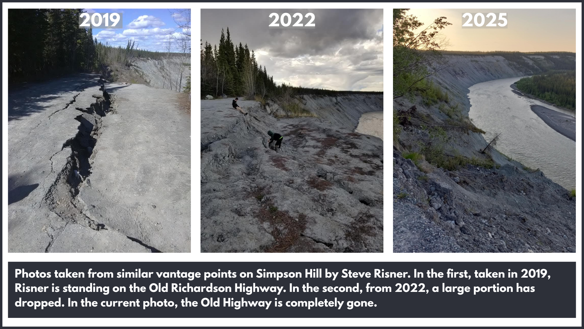
Mile 113 of the Richardson Highway, otherwise known as “Simpson Hill,” is set to be realigned by the Alaska Department of Transportation (DOT). The highway will be moved away from the bluff that descends steeply to the Copper River, and has eroded dramatically.
Federal funding for this project was approved July 14 as part of the 2024-2027 Statewide Transportation Improvement Program (STIP) Amendment 2. The total project budget is just shy of $1.6 million. DOT will install guardrails and begin design work this summer.
Meanwhile, some residents have expressed concern that the situation is urgent. Ken Soldin, who currently resides in Lake Louise but spent his career in quarries in Southeast, stated he fears “It is imminent at any moment to slide.”
Local resident Steve Risner has observed and photographed “trees splitting from the bottom,” on the hill, demonstrating movement of the land beneath. He said he was “shocked at how much it’s changed from year to year.”
I asked DOT Public Information Officer Angelica Stabs some questions about the area, which the DOT has stated it is monitoring.
What is the frequency of monitoring?
Our crews are regularly in or passing through the area as part of their routine operations. This ongoing presence allows us to observe conditions and respond as needed.
What tools or techniques are being used?
We utilize a combination of tools and techniques to monitor the area, including land and drone surveys, historical aerial imagery, past readings from slope monitoring instruments and observations from our Maintenance and Operations crews. These methods have been used for decades and continue to provide valuable insight into ongoing conditions, helping to inform any necessary response.
Is there a certain predetermined threshold or observation that would trigger another phase of dealing with this section of highway?
The Alaska Department of Transportation and Public Facilities is committed to keeping the roadway safe for travelers and will continue to take the necessary steps to maintain public safety. If we observe a significant increase in erosion or other notable changes, we will take appropriate action. Our response is based on current site conditions and informed by regular observations from our crews and monitoring tools.

Tree split from the bottom due to shifts in the ground beneath on Simpson Hill. Photo by Steve Risner.
If at some future time the highway is found to be unsafe in that section, what options would the department have?
If this section of highway no longer meets current design standards before a full realignment can occur, we will implement temporary mitigations to keep the highway passable and safe for the public.
What would DOT like the public to understand about this issue?
We want the public to know that we are actively monitoring the slope and fully recognize it as a long-standing situation. At this time, the roadway remains safe for travel.
Through the Statewide Transportation Improvement Program (STIP), this project (#34768) has been approved for a full highway realignment. This project will relocate the highway farther from the eroding bluff, rebuild the roadway, and improve drainage to manage runoff and prevent future slope movement. As a proactive measure, we will be installing guardrail in the affected area this summer.
Disclosure: Alaska DOT is a Copper River Record advertiser. This did not influence our coverage.